Tobacco farming history
By Carl Fleischhauer and Art Cochran
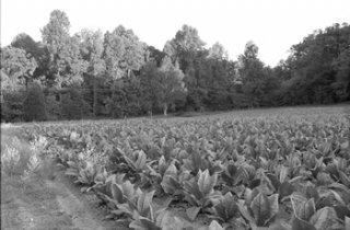 Tobacco growing on an ACLT field on Scientists Cliffs Road, 1998.
Tobacco Country. Tobacco became the principal and characteristic crop of the Chesapeake region shortly after the establishment of the English colony of Maryland in 1634 and it was the dominant cash crop in Calvert County for more than 350 years. Tobacco defined agriculture in Southern Maryland throughout this time period and, in turn, defined the cultural landscape of Calvert County.
Demographics. Tobacco is a labor-intensive crop, a fact reflected in Calvert County's demographics. For more than a century, the African Americans who provided much of the tobacco workforce outnumbered the county's white population. In 1790, the county was home to 4, 211 whites and 4, 441 blacks (about 51 percent), 136 of whom were free. By 1850, there were 3, 630 whites and 6, 016 blacks (about 60 percent), 1, 530 of whom were free. By 1890, the percentage of African Americans had again dropped to 51 percent, representing about 5, 000 of the county's 9, 860 residents. About one century later, the 2000 census reported a county population of about 74, 000 persons, of whom about 63, 000 were white and 9, 800 were African American.
Settlements. Most 18th and 19th century communities were defined at their core by a church, school, business, or a few closely-spaced houses. They did not have formal boundaries and shaded off into adjacent rural or farm neighborhoods. The dispersal of residents in earlier days reflects Calvert's agricultural character and the historical importance of water transportation.
Steamboat Landings. Travel and commerce by water shaped the Chesapeake's cultural landscape, nowhere more than in narrow, peninsular Calvert County, with its many easily accessible steamboat wharves. During the 19th century and the first quarter of the 20th, hogsheads (large, wooden casks) of tobacco were taken to market in Baltimore by steamboat. Most farms had a tobacco prize—a large press used to compress the tobacco for shipment—and the filled hogsheads were rolled or carried by wagon to the steamboat landing. The farmers south of Parkers Creek met the steamboat at Governors Run, and many traveled to the Bay and the wharf along the road that is now the lane into Eastview Farm, past its barns, and southeast down the slope, where the old road can still be clearly seen. (North of Parkers Creek, the nearby steamboat wharf was Dare's, in the community now known as Dare's Beach.)
Cleared land. During the period when tobacco farming prevailed, most of the land outside of deep ravines consisted of cleared fields. An 1847 map suggests that, by the middle of the 19th century, most level sections in the ACLT's south-of-the-creek holdings had been cleared for tobacco. Robert "Bobby" Weems of Port Republic has recalled Emory Howard's farm in 1936 as "the prettiest place on the Bay." From Howard's house, a few hundred yards east of today's ACLT parking lot on Scientists Cliffs Road, one could "look halfway to Parkers Creek, to Kenwood Beach, " Weems said, "and [there] wasn't nary a wood, a tree" except in the ravines. Howard was a "very neat farmer, kept everything just as clean-cut all down, " Weems said.
Spartina grass (cordgrass) in the Parkers Creek marsh, 1995.
Parkers Creek. The creek was too shallow to serve the needs of water transportation and its lands too moist or steep to serve agriculture, although the Spartina grasses (cordgrass) that flourish in the tidal flats near the Bay may have provided fodder for livestock. The area did support timbering and sawmills, however, and some African American residents recall hearing about relatives who cut railroad ties and floated them down the creek to waiting steamboats in the years around the turn of the century. In addition, wildlife, including muskrats and terrapins, were certainly harvested by families in the region.
Parkers Creek bridge photographed by Annie Karrer. The family album in which this picture was found was labeled 1937-1945. From the Scientists' Cliffs Association Archives.
Road crossing Parkers Creek abandoned. The creek was a place you had to cross as you traveled by road from Port Republic to Dare's Wharf or Prince Frederick. The public road and bridge lasted until the late 1930s, by which time the increased availability of automobiles and the existence of better albeit less direct roads meant that people could reach the county seat by going west and then north, via the county's main road, today's Maryland state highway 2-4. The need for a short cut across the creek was no longer strongly felt.
VIDEO REVIEWS


Share this Post
Related posts
Colonial tobacco farming
By 1640, London was importing nearly a million and a half pounds of tobacco annually from Virginia. Soon English tobacconists…
Read More
Tobacco history facts
Nicotine was isolated from tobacco leaves ( Nicotiana tabacum ) in 1828, but the powerful effects of nicotine were already…
Read Morelatest post
-
 Historical smoking July 18, 2024
 -
 Tobacco history Timeline July 8, 2024
 -
 Cigarette smoking causes June 28, 2024
 -
 What is the History of lung cancer? June 18, 2024
 -
 Anti Tobacco products June 8, 2024
 -
 Surgeon General History May 29, 2024
 -
 Smoking-Related lung cancer May 19, 2024
 -
 The history of cigarettes May 9, 2024
 -
 U.S. smoking April 29, 2024